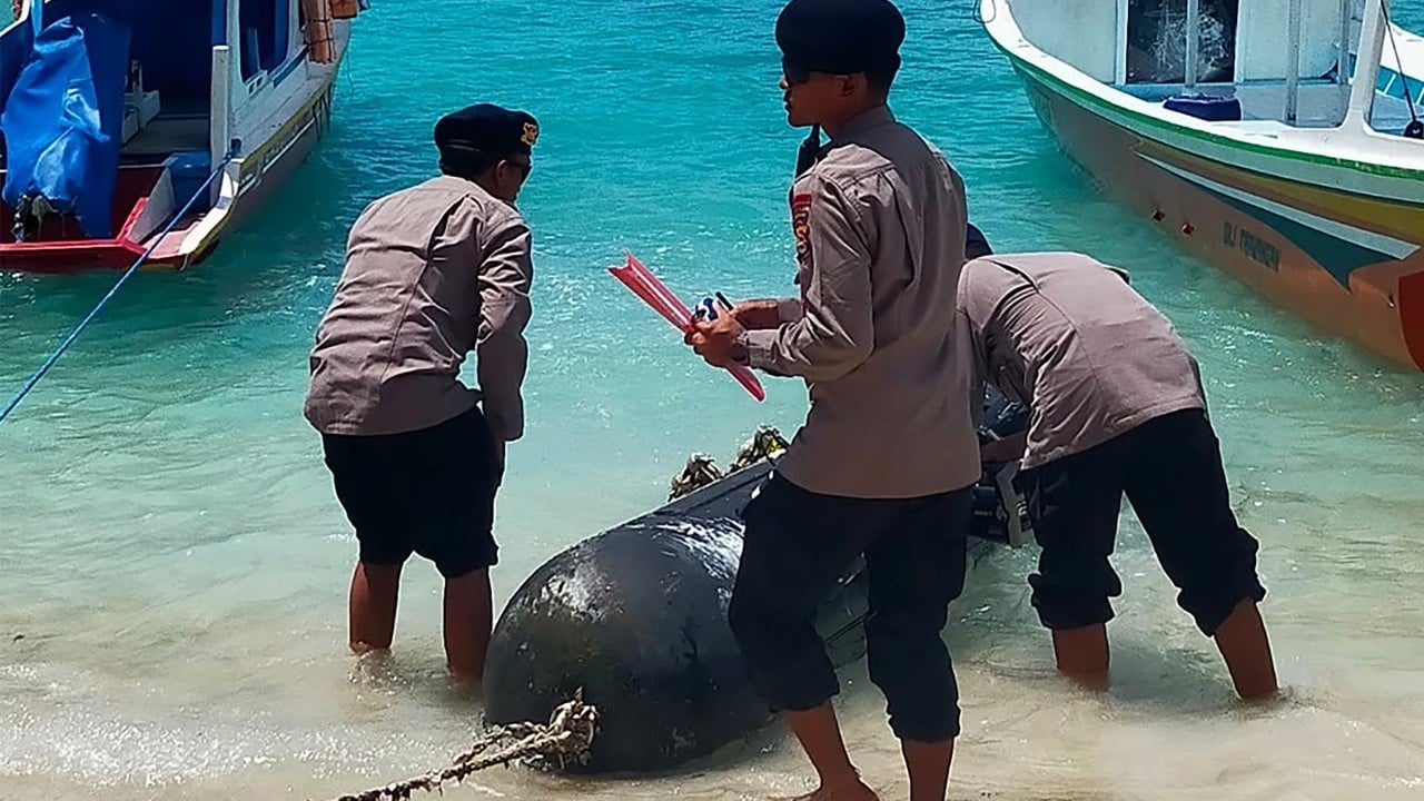
The discovery of a Chinese-made Sea Wing (Haiyi) Unmanned Underwater Vehicle (UUV) by an Indonesian fisherman near Selayar Island is not an isolated maritime anomaly; it is a data point confirming a systematic shift toward autonomous subsurface intelligence, surveillance, and reconnaissance (ISR). The incident exposes the intersection of hydrographic data collection and the strategic requirement for "acoustic transparency" in deep-water corridors. Understanding this event requires moving beyond the sensationalism of a "spy drone" and analyzing the specific mechanical, geopolitical, and operational frameworks that govern the deployment of such assets.
The Mechanical Taxonomy of the Sea Wing Glider
To analyze the threat profile of this UUV, one must first categorize its propulsion and persistence. Unlike traditional torpedo-shaped UUVs that rely on high-output propellers and lithium-ion batteries—which offer high speed but limited endurance—the Sea Wing is a maritime glider.
The Physics of Buoyancy-Driven Propulsion
The Sea Wing operates on the principle of variable buoyancy. It contains an internal bladder that expands or contracts to displace water.
- Descent: The bladder shrinks, increasing the vehicle's density, causing it to sink. Small wings convert this vertical motion into forward glide.
- Ascent: The bladder expands, the vehicle becomes positively buoyant, and it glides back toward the surface.
- Data Transmission: Once at the surface, the vehicle extends an antenna to transmit GPS coordinates and collected sensor data via satellite before beginning the next cycle.
This sawtooth flight path allows the glider to operate for months without a traditional engine. It consumes minimal energy, making it an exceptionally quiet platform that is virtually undetectable by passive sonar arrays designed to track the mechanical signatures of submarines.
The Strategic Objective: Hydrographic Data as a Weapon
The capture of the Sea Wing occurred in the Selayar Islands, a region that sits along a critical maritime chokepoint: the transition from the Flores Sea to the Makassar Strait. This is a primary deep-water route for submarines traveling between the South China Sea and the Indian Ocean. The utility of the UUV in this specific geography is dictated by three primary data requirements.
1. Thermocline Mapping and Acoustic Propagation
Sound travel in the ocean is not linear. It is governed by temperature, salinity, and pressure. The Sea Wing’s primary payload consists of CTD (Conductivity, Temperature, and Depth) sensors.
- The Layer Effect: Drastic changes in water temperature (thermoclines) can reflect or refract sonar waves.
- Operational Advantage: A navy that possesses a high-resolution map of these layers can hide submarines in "shadow zones" where sonar cannot penetrate. Conversely, it allows them to calibrate their own sonar to detect "silent" adversaries.
2. Bathymetric Contouring
Deep-water navigation for nuclear-powered submarines requires precise maps of the seafloor to avoid detection by staying close to underwater features. The Sea Wing provides the high-fidelity terrain mapping necessary for autonomous navigation systems in future combat UUVs.
3. The Salinity Gradient
In Indonesian waters, the "Indonesian Throughflow"—the movement of water from the Pacific to the Indian Ocean—creates complex salinity variations. These variations affect the buoyancy of a submarine. For a submarine commander, knowing the exact salinity profile of a strait before entry is the difference between maintaining "silent trim" and having to use loud mechanical pumps to adjust depth.
The Legal Vacuum and Grey Zone Tactics
The deployment of the Sea Wing in Indonesian sovereign waters highlights a deliberate exploitation of the United Nations Convention on the Law of the Sea (UNCLOS). The ambiguity lies in the definition of "Marine Scientific Research" (MSR).
The MSR Defense
China often classifies these deployments as pure oceanographic research aimed at environmental monitoring or disaster prevention. Under UNCLOS, MSR in another nation's Exclusive Economic Zone (EEZ) requires consent. However, the distinction between "scientific research" and "military hydrographic surveying" is legally murky.
By using an unarmed, slow-moving glider, the deploying state maintains "plausible deniability." If caught, they claim a technical malfunction caused the unit to drift off course. If not caught, they harvest the dual-use data required to map submarine "bastions."
The Sovereignty Calculus
For Indonesia, the presence of these drones represents a breach of the Archipelagic Sea Lanes (ASL). The passage of foreign vessels is permitted, but the active collection of data—essentially "mapping the backyard" of a sovereign state—falls outside the definition of innocent passage. The seizure of the drone is a physical manifestation of a counter-ISR strategy, yet the cost-exchange ratio remains skewed. A glider costs approximately $50,000 to $100,000; the intelligence it gathers over a six-month deployment is worth millions in strategic positioning.
The Operational Lifecycle of Subsurface ISR
To understand why this drone was found, we must look at the "failure modes" of autonomous maritime systems.
- Entanglement: The most common cause of glider loss. Shallow waters near the Indonesian archipelago are densely populated with fishing nets. The glider’s slow speed (typically 0.5 to 1 knot) makes it incapable of breaking free from monofilament lines.
- Sensor Fouling: Bio-growth on the wings or sensors can degrade glide efficiency, forcing the unit to surface prematurely or drift into currents it cannot overcome.
- The Recovery Gap: These units are usually recovered by Chinese survey vessels like the Xiang Yang Hong series. If a glider drifts into high-traffic or politically sensitive areas, the recovery ship may abandon the asset to avoid a direct diplomatic confrontation, leaving the unit to be found by local populations.
Systemic Implications for Regional Security
The presence of the Sea Wing is a precursor to the "Undersea Great Wall," a networked sensor array designed to monitor underwater movement in the "First Island Chain." The deployment of gliders serves as the mobile component of this network.
Data Aggregation and Machine Learning
The value is not in a single glider’s data, but in the aggregation of thousands of "sawtooth" profiles. When fed into naval modeling software, this data allows for the creation of 4D oceanographic models. These models predict how the underwater environment will change based on seasonal currents, allowing for predictive acoustic modeling. This effectively shrinks the "oceanic haystack," making it significantly easier to find the "needle" of an enemy submarine.
The Shift to Swarm Logic
The Sea Wing incident demonstrates a transition from high-value, manned platforms to low-cost, expendable autonomous swarms. Losing one drone to a fisherman is an acceptable loss in a strategy that prioritizes data volume over individual asset security.
The Counter-Autonomous Framework
To mitigate the advantage gained by these deployments, coastal states must move beyond reactive seizures and adopt a proactive "Digital Maritime Domain Awareness" (DMDA).
- Acoustic Fingerprinting: Developing databases of the specific buoyancy-pump frequencies used by different glider models to trigger automated alerts via stationary hydrophone arrays.
- Legislative Tightening: Explicitly defining "military hydrographic survey" in domestic law to allow for the immediate confiscation and exploitation of captured autonomous hardware without the need for prolonged diplomatic negotiation.
- Cyber-Physical Interception: Rather than physical recovery, electronic interference with the glider’s satellite uplink can be used to "spoof" GPS coordinates, leading the drone into controlled recovery zones.
The Sea Wing found in the Selayar Islands is a warning that the subsurface domain is no longer a silent void, but a contested data environment. The strategic priority for regional powers is now the development of "anti-access" capabilities that extend beneath the waves, targeting the sensors that make modern submarine warfare possible. The era of the "unseen" ocean is over; the era of the mapped, modeled, and monitored ocean has begun.