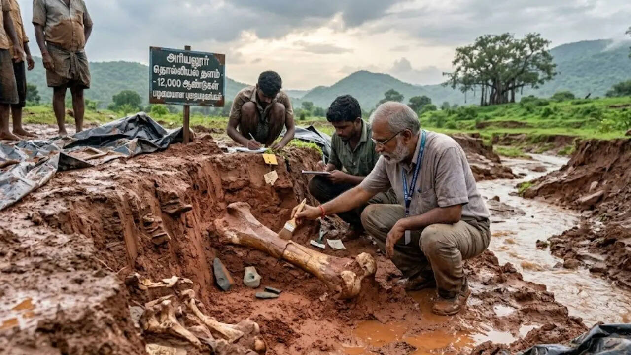
The discovery of a 12,000-year-old prehistoric site in Tamil Nadu, precipitated by hydraulic erosion during heavy monsoon rains, represents more than a localized archaeological find; it is a fundamental disruption of the established chronostratigraphic timeline for the Indian subcontinent. While surface-level reporting focuses on the visual novelty of unearthed artifacts, a rigorous strategic analysis identifies this as a critical data point in mapping the transition from the Late Pleistocene to the Early Holocene. The site serves as a physical ledger of human adaptation strategies during a period of significant climatic volatility.
The Mechanism of Discovery: Hydraulic Exposure vs. Systematic Excavation
Traditional archaeological site identification relies on predictive modeling based on proximity to perennial water sources and elevated topography. However, this specific site in Tamil Nadu remained obscured until heavy rainfall acted as a natural excavation force. This process, known as hydraulic stripping, removed the overburden—the top layers of soil and sediment—to reveal lithic assemblages that had been sealed for millennia. You might also find this related coverage interesting: Why Taiwan Should Fear Being On The Menu For The Trump-Xi Summit.
The sudden appearance of these artifacts introduces a technical challenge: the loss of primary context. In a controlled excavation, the precise horizontal and vertical coordinates of an object (provenance) are mapped to determine its temporal placement. When artifacts are moved by rainwater or exposed via erosion, the "stratigraphic integrity" is compromised. To rectify this, analysts must look at the "Three Pillars of Lithic Analysis":
- Typological Classification: Determining the tool's purpose and manufacturing technique (e.g., microliths vs. macro-tools).
- Raw Material Sourcing: Identifying if the stone is local or transported, which indicates trade networks or migratory patterns.
- Use-Wear Analysis: Microscopic examination of the edges to determine if the tools were used for hunting, hide scraping, or vegetative processing.
Categorizing the Tamil Nadu Assemblage: The Technological Pivot
The artifacts found—primarily stone tools and debitage (the waste flakes produced during tool making)—signal a specific technological stage. The 12,000-year mark places this site at the cusp of the Mesolithic era. During this phase, human populations moved away from heavy, cumbersome hand-axes toward "microlithic" technology. As reported in recent articles by The Washington Post, the effects are notable.
The Efficiency Function of Microliths
The shift to microliths was not aesthetic; it was a response to an optimization problem. Small, razor-sharp stone flakes were designed to be "hafted" (attached) to wooden or bone handles. This modular approach to tool-making offered three distinct advantages:
- Resource Conservation: A single core of high-quality stone could produce dozens of small blades, whereas a Paleolithic hand-axe consumed the entire core for one tool.
- Weight-to-Lethality Ratio: Projectiles (arrows and spears) became lighter and more accurate, increasing the caloric return on hunting efforts.
- Repairability: If a single microlithic tooth in a composite saw or harpoon broke, it could be replaced without discarding the entire implement.
The Tamil Nadu site confirms that the hunter-gatherer groups in South India were operating at a high level of technical proficiency, utilizing local quartz and chert to maintain these modular systems.
The Paleo-Climatic Correlation
To understand why this site exists where it does, one must analyze the environmental variables of the Late Pleistocene. 12,000 years ago, the Earth was exiting the Last Glacial Maximum (LGM). The "Climatic Forcing Function" in South India during this era involved a strengthening of the monsoon systems.
The increased rainfall led to a densification of the deciduous forests. This environmental shift forced a change in human "subsistence strategies." The large megafauna of the open plains were replaced by smaller, faster forest-dwelling species. The tools discovered in Tamil Nadu are the hardware required to survive this specific software update in the Earth's climate. The density of the find suggests a semi-permanent settlement, indicating that the local ecosystem provided a high enough carrying capacity to support sedentary or semi-sedentary behavior before the advent of formal agriculture.
Mapping the Logic of Cultural Continuity
A common error in analyzing South Indian prehistory is viewing these sites as isolated incidents. Instead, they should be viewed as nodes in a broader "Lithic Complex." The Tamil Nadu discovery creates a geographic bridge between the well-documented sites in the Belan Valley of the North and the prehistoric sequences in Sri Lanka.
This creates a "Diffusion Pipeline" theory. If the technology at the Tamil Nadu site shows stylistic similarities to contemporaneous sites in the Deccan Plateau, we can quantify the rate of cultural transmission. If the styles are distinct, it suggests "Independent Innovation," where local populations developed specific solutions to local environmental pressures without external influence.
The Bottleneck of Preservation and Urban Encroachment
The primary threat to the data integrity of this 12,000-year-old site is not time, but contemporary land use. In the "Cost-Benefit Analysis" of regional development, archaeological sites often lose out to infrastructure. The Tamil Nadu site, having been exposed by rain, is now vulnerable to:
- Oxidative Degradation: Soil chemicals reacting with newly exposed organic materials (if any remain).
- Anthropogenic Disturbance: Unauthorized collection or construction activity.
- Secondary Erosion: Subsequent rain cycles that may wash the artifacts into riverbeds, permanently stripping them of their chronological context.
The strategic priority for the state archaeological department is not the collection of "pretty stones," but the preservation of the "stratigraphic column." The soil surrounding the tools contains pollen grains (palynology) and phytoliths (silica structures from plants) that provide a high-resolution map of the 12,000-year-old environment.
Advanced Dating Protocols: Beyond Carbon-14
While Carbon-14 dating is the standard for organic materials, it is often ineffective for stone tools. To provide a rigorous date for the Tamil Nadu site, analysts must employ Optically Stimulated Luminescence (OSL).
OSL measures the last time individual grains of quartz or feldspar in the soil were exposed to sunlight. By dating the soil layer directly above and below the tools, researchers can "bracket" the age of the site. This removes the guesswork inherent in surface finds and provides a statistically significant timeline that can withstand peer-reviewed scrutiny.
$$T = \frac{D_e}{\dot{D}}$$
In this equation, $T$ is the age of the sample, $D_e$ is the equivalent dose (the radiation absorbed by the mineral during burial), and $\dot{D}$ is the dose rate (the annual radiation from the surrounding environment). Using this mathematical framework allows for a precision that anecdotal reporting lacks.
Strategic Recommendation for Regional Archaeological Management
The discovery in Tamil Nadu necessitates a shift from reactive archaeology to predictive remote sensing. Given that heavy rainfall acted as the catalyst, the following protocol should be implemented to identify high-probability "shadow sites" in the region:
- LiDAR Mapping: Utilize Light Detection and Ranging to strip away modern vegetation data and reveal the "paleo-topography" of the region. This identifies ancient river terraces where 12,000-year-old populations were likely to congregate.
- Hydrological Modeling: Run simulations of heavy rainfall runoff patterns to identify areas where soil erosion is most likely to expose deeper stratigraphic layers.
- Geochemical Proximity Sensing: Testing soil for elevated phosphate levels, which often indicate ancient human occupation sites due to decomposed organic waste.
The Tamil Nadu site is a high-fidelity signal in a low-noise environment. It demands a move away from the "discovery" narrative toward a "data-integration" model, where each artifact is treated as a variable in the larger equation of human migration and survival in the Indian subcontinent.
The immediate move is to establish a "buffer zone" around the hydraulic exposure points and initiate deep-trench OSL sampling. Failure to do so before the next monsoon cycle will result in the permanent loss of the most significant Late Pleistocene data set in Southern India.