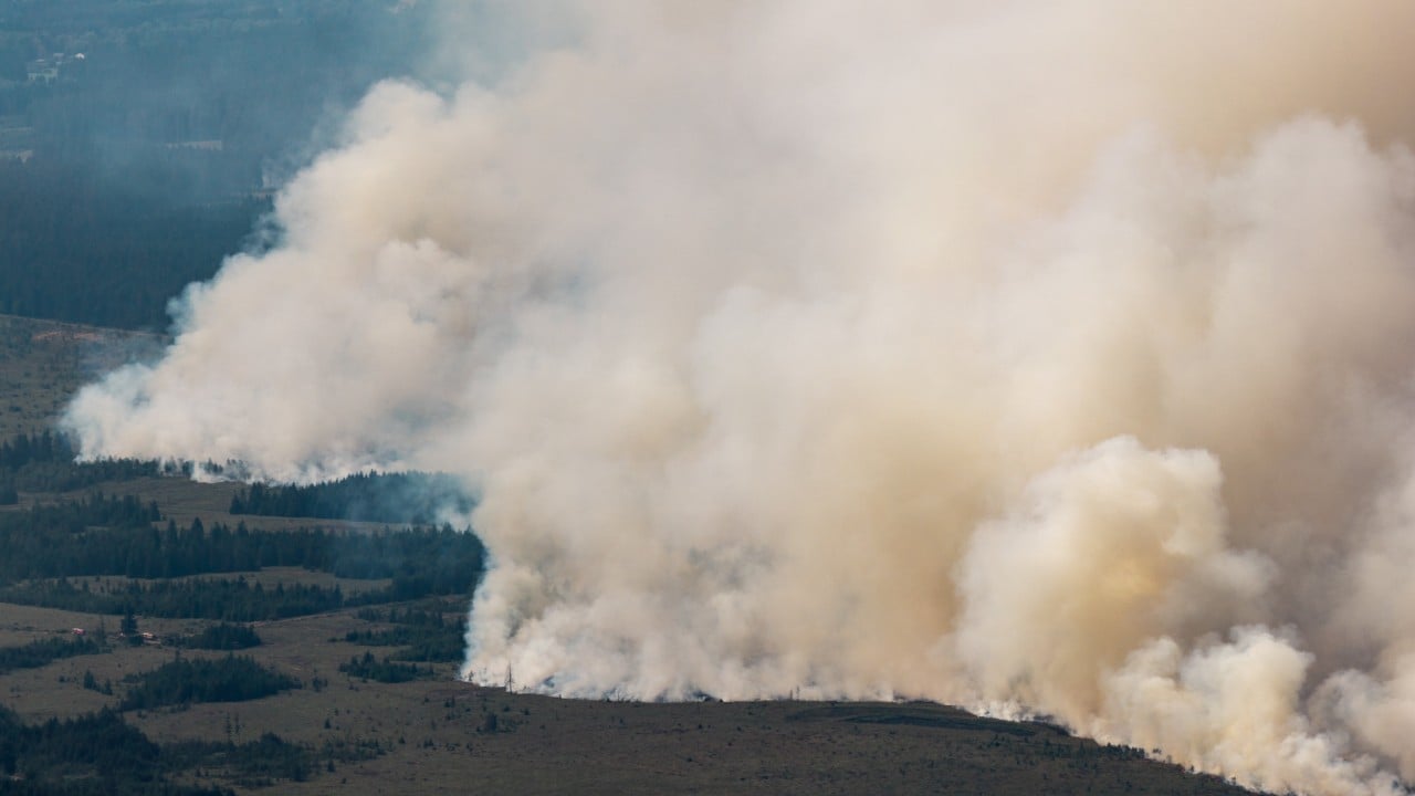
The physical security of Western Europe is undergoing a systemic stress test as environmental anomalies override historical baseline assumptions. In eastern Belgium, the High Fens nature reserve has transformed into the site of the largest wildfire in the nation's modern history, consuming approximately 2,700 hectares of fragile peatlands and pine forests.
This event is not merely an isolated weather anomaly; it represents a profound failure mode in national ecological buffering capacity, logistical deployment speed, and cross-border resource allocation. Deconstructing the mechanics of this disaster reveals structural vulnerabilities in how densely populated European states manage catastrophic climate-driven contingencies.
The Three Structural Vectors of the Crisis
The escalation of the High Fens fire from a localized ignition into a national emergency is governed by three distinct, interlocking variables: hydrological depletion, terrain topology, and atmospheric momentum.
[Atmospheric Heatwave]
       │
       ▼
[Peatland Desiccation] ──> [Subsurface Ignition Risk] ──> [High-Friction Topography] ──> [Logistical Paralysis]
1. Hydrological Desiccation and Subsurface Fuel Load
The High Fens ecosystem is characterized by extensive peat bogs—organic soils that function naturally as carbon sinks and hydrological sponges. Decades of drainage and successive summer heatwaves, culminating in the fifth major thermal wave of the season, have driven the volumetric water content of the soil down to critical thresholds.
When peat desiccation reaches these levels, fires cease to behave as simple surface vegetation events. The combustion vector moves underground. Subsurface peat fires possess low oxygen requirements and high thermal retention, rendering standard direct-attack suppression tactics ineffective. Water dropped from aerial assets often evaporates before penetrating the smoldering organic layers, requiring sustained, intensive saturation protocols that exhaust regional water supply chains.
2. Topographical Friction and Ground-Level Inaccessibility
The physical geography of the High Fens acts as a severe operational bottleneck. The reserve features undulating terrain, dense pine stands, and marshy ground matrices that preclude the deployment of heavy mechanized firefighting vehicles.
Ground crews operating in these environments face extreme transit friction. Fire engines and transport trucks are confined to perimeter firebreaks, forcing personnel to rely on manual line-cutting and backpack units. This geographic constraint creates an inverse relationship between fire perimeter expansion and ground response velocity. As the fire front accelerates under high winds, the manual deployment rate of containment lines drops below the propagation rate of the blaze.
3. Atmospheric Momentum and Microclimate Volatility
Surface wind vectors in eastern Belgium shifted dynamically during the ignition phase, transforming a predictable linear burn into a multi-directional perimeter threat. High ambient temperatures peaking near 37 degrees Celsius created localized thermal updrafts. These updrafts generated erratic ember casting, breaching established natural firebreaks like streams and access tracks.
The resulting smoke plumes forced the evacuation of surrounding villages, a children's summer camp, and regional tourist infrastructure, compounding municipal coordination challenges by introducing civilian evacuation traffic onto narrow rural transit corridors.
The Mechanics of Transnational Resource Mobilization
Because domestic firefighting assets are dimensioned for median historical risk profiles rather than tail-risk megafires, national command structures reached saturation within forty-eight hours of the initial ignition. To prevent total containment failure, Belgium executed an immediate activation of the European Union Civil Protection Mechanism and its associated rescEU reserves.
┌────────────────────────────────────────────────────────┐
│               Belgian Command Authority                │
└                           ┬                            │
                            │ Activation Request         │
                            ▼                            │
┌────────────────────────────────────────────────────────┐
│     Emergency Response Coordination Centre (ERCC)      │
└   ┬───────────────────────┼───────────────────────┬    │
    │                       │                       │    │
    ▼                       ▼                       ▼
[Czechia]                [Sweden]              [Netherlands]
(Helicopter Asset)     (Water-Bombers)        (Tactical Support)
This cross-border intervention highlights the operational dependency of smaller European states on centralized continental asset pooling. However, the mobilization vector exposes clear latency costs:
- Transit and Deployment Lag: Aerial assets dispatched from Czechia, Sweden, and the Netherlands require mandatory transit windows, flight-crew rest cycles, and local airspace integration. In rapidly evolving peat fires, a 12-to-24-hour deployment delay allows fire perimeters to expand exponentially.
- Interoperability Friction: Coordinating disparate municipal, national, and international units—ranging from the Belgian army and local agricultural tractors to specialized Swedish water-bombers—creates command-and-control overhead. Radio frequency mismatches, differing tactical doctrines, and varying aircraft payload capacities complicate the real-time allocation of suppression resources.
The Economic and Ecological Cost Function
The total loss footprint of the High Fens disaster extends far beyond immediate suppression expenditures. The cost function of this event operates across three distinct time horizons:
Short-Term Operational Expenditure
Municipal and regional authorities incurred immediate costs driven by overtime compensation for over 250 firefighters, fuel consumption for heavy transport, and the economic indemnification of evacuated populations. Furthermore, the hourly operational costs of cross-border aerial assets draw heavily from emergency contingency budgets.
Medium-Term Infrastructure and Tourism Deficit
The temporary shutdown of regional tourism, hospitality operations, and transit routes through the Liege region strips immediate capital flow from the local economy. Infrastructure damage to local power grids, telecommunications masts, and forestry assets requires capital reallocation from planned municipal development.
Long-Term Natural Capital Depreciation
The destruction of carbon-sequestering peatlands releases centuries of stored organic carbon back into the atmosphere, converting the reserve from a carbon sink into a net emitter. The ecological recovery timeline for burned peat matrices spans decades, permanently altering local biodiversity and increasing the susceptibility of the terrain to future erosion and secondary ignition cycles.
Strategic Realignment for High-Density European Ecosystems
To prevent recurrence under accelerated climate projections, regional planning authorities must transition from reactive crisis management to preemptive structural hardening.
Municipalities must abandon the assumption that Central European ecosystems are immune to megafire dynamics. Disaster response frameworks require decentralized prepositioning of high-capacity mobile pumping units designed to draw water continuously from regional river networks, bypassing reliance on municipal mains during droughts. Furthermore, automated thermal drone surveillance networks must be deployed across high-risk nature reserves to detect subsurface peat anomalies before surface ignition occurs.
Resource allocation protocols must shift from manual, post-hoc international requests toward pre-negotiated bilateral standby agreements that compress deployment latency from days to hours.


